

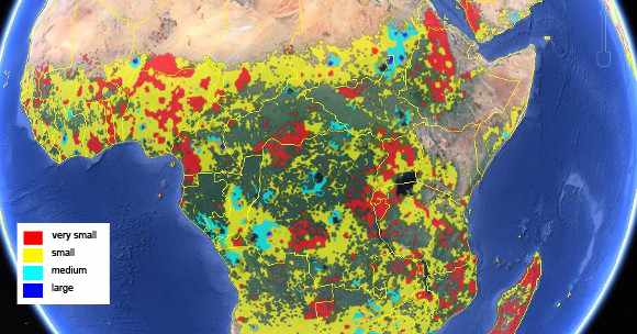
New maps offer a clearer view of global agriculture
Two new global maps have been published and providing a significant step forward in global cropland information. The maps offer an insight into global total cropland and field size.
The construction of the maps was led by researcher Steffen Fritz, based at International Institute for Applied Systems Analysis (IIASA) in Austria. Fritz is the holder of a 2013 Consolidator Grant from the European Research Council and is the creator of IIASA’s citizen science project. Fritz used the funding to develop the new maps as part of the ‘Harnessing the power of crowdsourcing to improve land cover and land-use Information’ (CrowdLand) project. The maps were developed by the IIASA and the International Food Policy Research Institute based in Washington DC in the USA.
The first map shows global cropland percentages at 1km resolution for the year 2005 and was created using a hybridisation of multiple data sources from different institutes and organisations. The map also used crowdsourcing validation data, which saw volunteers use high-resolution data to check the accuracy of larger scale maps.
The study also presents the first-ever global field size map, described as an important proxy for mechanisation and human development. This map was based entirely on crowdsourced data collected through IIASA’s Geo-Wiki project, a crowdsourcing initiative that relies on a global network of citizen scientists which have observed thousands of high-resolution images of land cover to determine whether cropland was present or not.
Speaking about the maps, Fritz described the developments as very beneficial. The researcher said: “Current sources of information on cropland extent are not accurate enough for most applications. The global cropland map is a low cost solution to fill this need. Crowdsourcing has incredible potential for gathering this type of information and it could be particularly valuable in Africa, where future food security is a major uncertainty.”
Adding her thoughts, IIASA researcher and co-author Linda See said that the hybrid approach used in the development of the global cropland map “produces a better integrated product than any of the individual global base maps currently available”.
The two maps are available in the journal Global Change Biology.